Arguably,
we had no need to revisit La Palma. We’ve been
there twice before and took a thorough look round the island two years ago
while waiting for Helen’s badly gashed finger to repair. In addition, from a sailing point of view,
it only has two marinas and one anchorage to investigate.
 |
| Annotated postcard of La Palma showing principal places referred to in this Blog |
 |
| Fellow cruisers at Bryan and Dorothy’s infamous lunchtime BBQ in 2014 showing solidarity with Helen as she tries (unsuccessfully) to stem the bleeding from her finger by elevating her arm, prior to being whisked off by ambulance to A&E. There she ended up with 5 stitches to hold together the gash caused by putting a knife through her finger while preparing avocados for guacamole to take to the BBQ. |
The
island well deserves its reputation as La Isla Bonita [the beautiful island].
We like it and we wanted to see it again.
To hell with research!
 |
Almond blossom in Punta Gorda in the north of La Palma |
Before leaving San Sebastián in La Gomera, we were joined for supper by Ian
Beavis, and Alan and Kate Richards, fellow cruisers. Ian has based his yacht in
the Canaries for the last fifteen years and has a good knowledge of the Canaries,
Madeira and the Azores. Very helpful
from our point of view. Alan is a
fellow member of the Ocean Cruising Club, one of only three members we’ve met
over the last six months.
 |
Enjoying a sundowner in the cockpit
before supper with Ian Beavis and Alan and Kate Richards
|
We also caught up with
Andy McCarter whom we met two years ago with his wife Paddy, who together run
Gomera Walking (www.gomerawalking.com). Paddy is the sister-in-law of Ros Rossetti,
a very long-standing friend of Helen.
We thought we’d missed them since we knew they had gone back to Ireland
for a big family wedding, but Andy had popped back to La Gomera to finish
tidying up his boat and do some admin at the end of the walking holiday season.
 |
Andy McCarter, who runs Gomera Walking,
joined us for a lunchtime drink |
We sailed the 60 miles
from San Sebastián to Tazacorte marina
on the west coast of La Palma. Initially, while travelling south around La
Gomera, we had to sail against a typically unforecast northerly coastal wind
before benefiting from the forecast southwesterly wind once we got offshore.
Thereafter we had a comfortable sail on a beam reach.
An
extinct crater, the Caldera de Taburiente, dominates the island of La Palma. The rim of the crater at the Roque de los Muchachos
in the north is the island’s highest point at 2426 metres. The volcanic crater,
at 9 miles wide, is one of the world’s largest.
 |
The collapsed rim of the Caldera de Taburiente seen from Island
Drifter while sailing up the west coast
|
 |
Roque de los Muchachos, at 2426 metres
the highest point on La
Palma
|
Nearby
is an Astro
Physical Observatory. Clear and cloudless skies, lack of light pollution
and an undisturbed airflow as a consequence of the mountain’s shape, all
contribute to making this Observatory one of the best in Europe.
 |
International Astro Physical Observatory,
close to La Palma’s summit |
La Palma’s last volcanic eruption
was in 1971 when lava flowed into the sea at the southern tip of the
island. A new lighthouse and saltpans
have been built on the lava.
 |
Sailing through the Wind Acceleration Zone (in 35 knots) at
the southern tip of La Palma. The lighthouse and dark lava stream from the last
volcanic eruption in 1971 can be clearly seen.
|
Sugar cane was once the principal source of income for the
island. La Palma rum is good and very
much a connoisseur’s choice. Today, sugar cane has been supplanted by banana plantations
that cover large swathes of the coastline like green blankets. Canary Island bananas are small, sweet and
delicious. Only M&S in the UK seem
to sell them.
 |
| The tiny Puerto Espindola was once a major port for the export of sugar cane. It is too shallow for yachts. |
 |
Bananas grow up
to and often within
many of the towns and villages |
La Palma’s location in the
west of the Canaries archipelago, previous lack of an international airport and
an absence of golden sandy beaches have ensured that tourism has not had a materially
adverse effect on the island.
 |
| Puerto de Naos on the west coast remains small but is nevertheless the largest holiday resort by far on La Palma |
Hiking opportunities have, however, always attracted visitors to the
island. Paths are well maintained and
signed, and accommodation and facilities have developed to meet hikers’ needs
on the principal routes.
 |
| A section of the GR131, the cross-island hiking trail that runs through every one of the Canary Islands |
 |
| Enjoying a drink and apple cake at the Mirador el Time (594m), overlooking the coastal plain, after having climbed the first part of the GR131 route out of Puerto de Tazacorte |
Tazacorte marina, where we based ourselves, is on the west coast of La
Palma facing the Atlantic. It has a
micro-climate of its own, being protected from the prevailing northeasterly
winds by the mountains and yet sufficiently far from them not to be adversely
affected by the cloud they generate.
The
marina has an enormous double breakwater.
Its outer wall, financed by the EU, was designed not necessarily to
protect the marina (although that is what it does) but also as part of a new
ferry port – which has not yet commenced operations! Another Canarian White Elephant, rather like that at Valle Gran
Rey in La Gomera! But the locals are
not complaining.
 |
| Tazacorte marina with enormous double breakwater |
The
breakwater, incidentally, also provides protection for the anchorage just
outside the port – making it a good anchorage over 5 metres of sand in all but
southerly winds. A cheap option for cruisers.
 |
The anchorage outside Tazacorte marina with the
Roque de los
Muchachos (the highest point on the island) visible in the background
|
 |
Anchorage viewed from the marina |
The
adjacent well-protected (it has its own breakwater) long black sandy beach
at Puerto
de Tazacorte was where Alonzo Fernandez de Lugo landed with his
Conquistadors in 1492 to claim the island for Spain. The old port’s colourful village has evolved as a quiet holiday
resort with a pleasant promenade and a few bars and restaurants.
 |
Puerto de Tazacorte’s excellent, well-protected black sandy beach with its small colourful town in the background |
The
old, significantly larger, town of Tazacorte is high on the hill overlooking the port and
marina. It has a splendid view of the surrounding coastline and countryside.
 |
| Colourful houses along Tazacorte town’s promenade overlooking the coast and countryside |
Santa
Cruz, on the east coast, the capital of the island, has the only other marina
in La Palma. We’ve been there twice
before. We were somewhat disappointed
this time, but not totally surprised, to find that the marina owners from
Lanzarote had not implemented their plans of 2014, to combat swell inside the
marina. As a consequence it has a poor
reputation with cruisers who generally avoid it.
 |
| Santa Cruz’s half-empty marina |
 |
| A pedestrianised street in the heart of Santa Cruz |
 |
Traditional
Canarian balconies on houses
along the seafront in Santa Cruz |
 |
| One of the many open-air bustling cafés in Santa Cruz |
When
we first went to the marina on our second Atlantic Circuit in 2010, it was in
the first stages of development but accepted visitors and was fairly
empty. It’s now finished, but a lot
emptier.
We
were personally not, on either of our visits, unduly inconvenienced by what
swell there was – but the weather was benign.
Indeed, we look back on the location with some affection. It was there that we met Fritz and Ingrid
Erkelenz on their boat Pico.
They were each in their own right long-distance and experienced sailors. We enjoyed their company and
they gave us a great send-off on our second Atlantic circuit by way of a
sumptuous German breakfast. We remained
in touch with them by email following their voyage to South America, and were
greatly saddened to hear that Ingrid had died of cancer two years later.

Fritz and Ingrid Erkelenz
on their yacht Pico
in Santa Cruz marina, La Palma, in 2010, where they
gave us an outstanding breakfast send-off prior to our departure on our second
Atlantic Circuit

We
enjoyed a fast downwind sail for the 52 miles from Tazacorte to Puerto de Estaca
at the northern end of El Hierro’s east coast.
 |
| Sailing south to El Hierro from La Palma |
El
Hierro, the most southwesterly of the Canary Islands, is the smallest, least
populated, most remote, tranquil and unspoilt of them all. It is also the least visited since it finds
it difficult to accommodate all but the smallest cruise liner and it is too far
from Tenerife by ferry for day visitors, since the one ferry stays in the port
overnight. The airport only deals with inter-island flights.
 |
| Chart showing locations in El Hierro referred to in this Blog |
Serious hikers have, however, always enjoyed walking in the island.
Punta Orchilla,
in the southwest extremity of El Hierro, is the official end of the GR131 hiking trail
that runs from one end to the other of the Canaries Archipelago through each
island.
 |
End of the GR131
hiking trail through
the Canaries Archipelago |
For
many centuries Punta Orchila was considered, by Europeans, to be the limit of the “known
world”. That, and the fact that
it has no magnetic variation, explains why it was chosen by Spain in 1634 as a prime meridian,
one of several at that time. It only
relinquished that status in 1884 following international recognition of the
Greenwich meridian.
 |
| Helen standing by the Meridian monument |
Nearly
all the distinctive features of the Canary Islands’ landscape are present in El
Hierro: mountain forests; volcanic
badlands; extinct volcanoes; smallholdings; banana plantations; fertile coastal
plains; colourful colonising shrubs; steep sea and shoreline cliffs. All it lacks are golden sandy beaches – the
focus of tourist development on other islands.
 |
Laurisilva cloud forest on the way up to the island’s summit |
 |
| Colourful primo-colonising shrubs |
A central ridge runs in a
long, semicircle around the bay of El Golfo in the north of the island. It is the remaining part of the rim of an
extinct volcano, the other half of which slipped into the sea some 50,000 years
ago.
 |
The remaining half of El Golfo’s extinct volcano viewed from the south. Today, its remaining fertile central basin is the principal “garden” on the island. |
 |
Canary Pines on
the narrow central ridge
around the El Golfo caldera
|
From a sailing viewpoint, the island is a bit limited, albeit well worth
visiting. The north coast, from which
the El Golfo caldera can best be viewed, is exposed to the Atlantic elements
and has no ports or anchorages of refuge for yachts.
There are now two good, albeit small, yacht-friendly ports (Estaca and
La Restinga) although unfortunately only two “overnight” anchorages – as a
consequence of the steepness of the foreshores.
Two
years ago when we visited Puerto de Estaca, the island’s only ferry and commercial port,
its well-enclosed inner harbour was full of local small craft on fore and aft
moorings. Visiting yachts were not
unwelcome, but could only berth against the east inner wall of the basin, which
could be very uncomfortable in a swell. Most visitors, therefore, gave it a
miss and went down to La Restinga.
 |
| Puerto de Estaca two years ago when yachts could only berth against the inner wall of the port because of the number of local boats on fore and aft moorings |
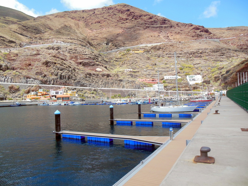
Recently,
new pontoons
have been installed with twenty places theoretically reserved for visiting
yachts and there is considerable free space available for further
expansion. When we arrived (and left)
there were no other visitors. Locals and absentee owners were already beginning
to fill the vacant visitors’ berths as appears to have happened in nearly every
Canarian port and marina.
There
is a very smart purpose-built shower block for use by visitors to the marina,
but it is not yet open because they are waiting for an electronic card entry
system to be installed. Meanwhile,
however, we were invited by the very pleasant and welcoming port police to use
their showers.
 |
The marina viewed
from
the GR131 winding up the hill above |
The
whole of the east coastline
is fringed by steep cliffs rising up to the island’s narrow summit and
plateau. From the sea, one can see a
scattering of isolated houses and small hamlets along the coast or clinging to
the lower slopes.
 |
The steep surrounding volcanic hill behind the marina leading
up to a narrow plateau at 600m
|
Valverde, the island’s
“capital” (little more than a small
town) is sited 9 kms by winding road from Puerto de Estaca on the plateau
above. It is the nearest place to the
port where one can purchase supplies, although a tiny village 2 kms along the
coast has a small shop. We chose to
walk to Valverde from the port along yet another part of the GR131. However, with only three buses a day, we
ended up catching a taxi back with our provisions.
El Hierro’s inter-island airport
is located on the coast on the other side of the headland north of Puerto de
Estaca.
 |
| El Hierro’s inter-island airport, bottom of photo, and the capital of Valverde at the top of the mountain |
The only two “viable” overnight
anchorages are close to and south of the port. Bahía de
Tijimiraque is only 1 km south in a
deeply indented cove with a small black sandy beach. It was formerly used as a
refuge in southerly gales by local fishing boats. Today one can anchor there in 5 metres over hard sand. It is well protected from winds from the
south through west to north.
 |
Bahía de
Tijimiraque anchorage to the south of Puerto de Estaca can provide good
protection from winds from south through west to north
|
Three
miles further south lies the second, even more sheltered and attractive, bay of
Bahía de
Bonanza, which provides protection from
winds from the southwest through to the northeast. When waves break offshore
only 200 metres to the east, the bay itself behind the Roque de Bonanza
(Fairweather Rock) can be totally calm.
Our reservations on this supposed anchorage were that the shore shelves
so steeply that one would need a significant length of chain. To anchor in
shallower water would result in one lying too close to the shore to be
comfortable. We also didn’t like the
look of the very large boulders on the seabed, since one would risk one’s chain
getting wound round them. We therefore
gave it a miss.
 |
The attractive bay at Bahía de Bonanza,
said to be a possible anchorage |
 |
Bahía
de Bonanza beach viewed from Island Drifter, with ten metres under our
keel. Far too close for comfort!
|
Two
years ago we based ourselves in Puerto de la Restinga on the southwest corner of
the island – a small but well-protected port from the prevailing northerly
winds. It has two massive breakwaters
and an inner mole to protect against swell in southerly gales. These days its principal function appears to
be to accommodate the local fishing fleet.
It does, however, welcome a limited number of visiting yachts, although
there are only two pontoons, well used by local craft.
 |
| Puerto de la Restinga viewed from hillside |
The
port was originally constructed as a refuge for fishermen working south in the
Atlantic, hence the presence of the brightly coloured Search and Rescue
craft. While we were there, four
offshore fishing boats from other islands pulled in for shelter in advance of a
southerly gale.
 |
| Offshore fishing boats that have taken shelter
in advance
of a southerly gale
|
The
adjacent village
of La Restinga is small but pleasantly arranged up the hill overlooking
the harbour. It has a couple of small
basic shops, a handful of restaurants and bars, some self-catering
accommodation for visitors and several dive schools.
 |
| La Restinga village viewed from the harbour’s breakwater |
In November 2011 an underwater volcano
erupted 2 kms off the town, which was evacuated for four months. Even today, when
the eruption is supposed to have subsided, locals understandably avoid the
area.
 |
Volcanic activity 2 kms off
Puerto de la Restinga in November 2011 |
Having been stuck in the Canary Islands for nearly three extra unplanned weeks two
years ago by strong northeasterly winds, we therefore now intend to treat our return to Lagos in
Portugal as our principal and only consideration.
Thanks for sharing such a great blog I am impressed with you taking time to post a nice information ….
ReplyDeleteThank you so much for such a wonderful blog. I’m really thankful to you for this informative…..
ReplyDelete