We
made landfall in Tenerife from Fuerteventura at Santa Cruz, the island’s
capital, from where we posted our last Blog (No 4).
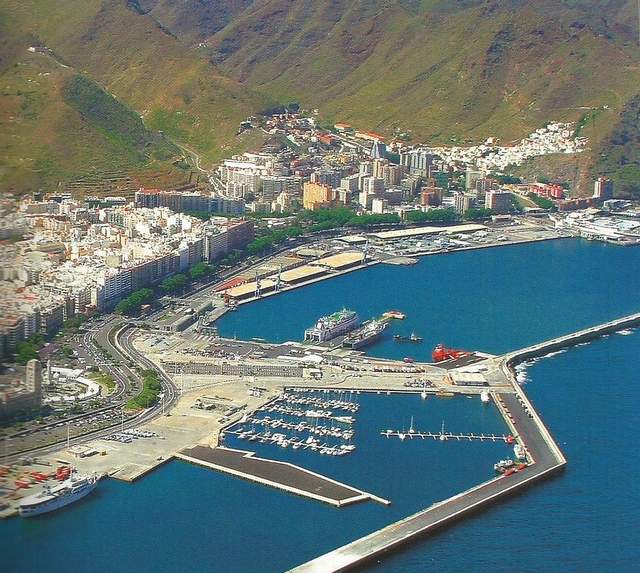
Santa Cruz marina and anchorage
viewed from hillside above
We’ve been to Santa Cruz several times before. We first went there in Island Drifter in December 1999 on our way to the Caribbean. At that time the port accepted, but made no provision for, visiting yachts. We simply tied up to a dock wall and made the best of it.

Cruising in the Canaries on our way
to the Caribbean in
1999
In 2001 we picked up a Contessa 32 (Dale Moon) for delivery to the UK. By then there were a few token pontoons in the dock at Santa Cruz. With a rare strong southerly wind all the way, we reached Lymington in 13 days without stopping! It was a fast but damp trip (see below). By the time we reached the UK, having provisioned for only a week, we were down to our last tin of baked beans and had each lost a few pounds in weight!

Helen and crew Martin halfway up and 100 miles off the Portuguese coast, running north with a strong wind behind and poled out with 3 reefs

Helen bailing out
the cockpit after being flattened by a rogue wave while crossing the Bay of
Biscay
Set in a large bay behind
the Anaga volcanic mountains to its north, Santa Cruz’s harbour is split into four
self-contained ports designed to accommodate the whole of the island’s
commercial, container, fishing, ferry, cruise liner traffic and local
boats. Marina Santa Cruz, by now a
privately operated visitors’ marina within the southern port of Darsena los
Llanos, evolved almost as an afterthought to fill space.

Chart of Santa Cruz
showing its four ports

Island Drifter
in Marina Santa Cruz with the Anaga mountains as its backdrop

Wash day following
our arrival – with city in the background
Santa
Cruz is a commercial
city and port. It is quite different from anywhere else in the Canaries,
other than Las Palmas, the capital of Gran Canaria. Even so, it differs subtly
from Las Palmas in that the pace of life seems more leisurely; large areas of
the city centre are either pedestrianised, traffic calmed or one-way streets,
and pavement bars, cafes, restaurants and parks abound.

Typical
side-street scene in the city

Traffic calming,
Santa Cruz style

One of the many
sculptures in the city’s parks and avenues
The
city has a rich
history and culture, both of which we explored on our last visit in
2014.

Ultra-modern Auditorium at the entrance
to the Darsena los
Llanos

Nuestra Señora
de Concepcion was built in 1502. It contains the cross carried by Spanish
troops when they landed in 1494. The tower and the balconies are fine
examples of Canarian architecture
that were added in the 18th Century

The old Saharan-styled gateway to
the
“African” market in Santa Cruz

A small sample of
the outstanding
produce on sale in the “African” market
Two years ago we stayed in Santa Cruz for a month and used it as a
base to recce the city and the island. We timed our visit then to coincide with
the city’s carnival week.

Carnival Queen
2014
This
year our aim
has been to cruise the coasts of each island and visit, in particular, those
marinas, ports and anchorages by sea, that we only managed to visit by land two
years ago.

Chart of locations in Tenerife referred
to in this Blog
Roughly
triangular in shape, Tenerife, 86 miles long, is the largest island in the
Canaries archipelago. It has a resident population of just under one million,
half of whom live in either Santa Cruz or La Laguna – the one-time capital of the
island which is now physically merged with Santa Cruz. A motorway and excellent tram system join
the two locations. The motorway also
extends along the north coast and down the east and south coasts of the
island.

One of the smart
trams that link Santa Cruz and La Laguna
Mount
Teide, in the centre of the island, dominates Tenerife. It can be seen, when not enshrouded in
cloud, from many parts of the island.
From its summit one can usually see the adjacent islands of La Gomera,
La Palma and Gran Canaria. The
mountain’s peak rises from one edge of the enormous central plateau of a
volcanic crater. At 3717 metres, Teide is the highest mountain in Spain. The summit is often covered in snow.

Mount Teide, as we saw it on our passage
along the north coast
of Tenerife
A
spine of volcanic mountains runs east to west through the middle of the island,
causing a dramatic difference in climate between the north and south: damper
and green in the north; drier and more arid in the south.

The German naturalist, Alexander von Humboldt,
who
‘discovered’ the Orotava Valley on the north coast of Tenerife and described it
as the most beautiful place he had ever seen
The 40 miles of relatively
narrow, low coastal volcanic plains leading to sea cliffs and small bays that
make up the east coast of the island down to Punta Rasca, contains, in our view, only
three marinas (Radazul, San Miguel and La Galletas) and two anchorages (Bahía
Abona and Playa de las Tejitas) that are suitable and accessible to cruisers
for overnight stops. We wouldn’t leave
our boat unattended for any length of time in the other anchorages on this
coast.
The
marinas operated by Clubs Nautico (sports and social clubs for members only)
don’t generally want to know you, the commercial harbours including the power
station (understandably) certainly don’t, while the small fishing ports
protected by breakwaters are so full of buoys (and sometimes boats!), that you
couldn’t get in, even if you were welcome.

Puerto de Candelaria, a typical example of a
small fishing
harbour where there is no room for visitors
Marina Radazul, which we sailed to next after leaving Santa Cruz,
is family owned and managed. It is tucked neatly behind a headland and is well
protected by the steep volcanic cliffs of the peninsula which are “lined” with
tall apartment blocks.

Marina Radazul, overlooked by steep volcanic cliffs
lined with tall
apartment blocks
Both
the marina and its boatyard are small, clean, efficient and secure. The unpretentious on-site bars and
restaurants add to its pleasant relaxed atmosphere.

Helen enjoying a
tapas supper at a marina bar
We
hiked along the coastal path from Radazul to Candelaria, although we did catch
the bus on the way back! On the way we stopped for lunch at a chuck wagon. Our first (Spanish) bifana
was excellent: a large roll filled with thinly sliced spicy marinated pork,
cheese and tomato.

Al fresco lunch – a
Spanish 'bifana' with a local beer
We
particularly wanted to visit Candelaria, a place of pilgrimage dedicated to
Tenerife’s patron saint. The black
wooden figure of Nuestra Señora de la Candelaria, a Guanche idol, is housed in
the old Catholic basilica and ‘guarded’ by the huge bronze statues of the nine
Guanche kings who governed the island before the Spanish conquest.

Basilica in
Candelaria containing
statue of Tenerife’s patron saint

Nuestra Señora
(Our Lady) de Candelaria

Large bronze statues of the Guanche Kings
who ruled the island
before the Spanish Conquest
Before
leaving Radazul, we FaceTimed our son Will and daughter-in-law Lesley on our
granddaughter Emelia’s first birthday.
Improved internet, MIFI, FaceTime, Skype, Google, Amazon, the capacity
to send receive photos and videos, and internet banking have dramatically
improved communications and life for cruisers. Helen, these days, can even do her copy editing and proofreading on line – something that was impossible ten years ago.

Helen FaceTiming Emmy from Santa Cruz
while sitting on the marina’s patio and using the free WIFI connection

Emmy, our
granddaughter, celebrates her first birthday
Bahía de Abona, the first apparently good overnight anchorage we
came to after leaving Radazul, was so full of old unused mooring buoys that in
the end we gave it a miss. The other
anchorage to the south of this bay, under the lighthouse, was empty of buoys
and would have made an excellent refuge in the event of southerly winds.

Northern anchorage at Bahía de Abona – excellent
protection and holding but useless for cruisers since it’s full of abandoned
mooring buoys and there is therefore inadequate swinging room for an anchored
yacht

Southern
anchorage at Bahía de Abona – an
excellent anchorage and refuge in southerly
winds.
Not surprisingly, the prevailing wind was from
the northeast and so we
didn’t stop overnight
We
ended up that night anchoring for a couple of days in Playa de las Tejitas, south of
the Punta
Montaña Roja (Red Mountain) – well protected from northeasterly winds by
the mountain on the peninsula and the indented shape of the bay.

At anchor in Playa de las Tejitas, under the Red Mountain,
with a reefed mizzen sail set for stability
The
anchorage is close to four enormous yellow mooring buoys used by tankers while
pumping fuel ashore to the nearby international Reina Sofia airport. We took particular care to anchor in shallow
water away from the buoys and to ensure that our hook avoided the submarine
pipelines that carry the fuel!

Chart plotter
showing Island Drifter anchored in the lee of Montaña Roja. Note yellow
mooring buoys used by tankers to refuel the nearby international Reina
Sofia airport!

View from our boat of the beach at Playa de las Tejitas,
with
a plane taking off from the airport
Marina San Miguel, south of Montaña Roja, is another family-owned and
-run marina. It was built in conjunction with the Amarilla Golf and Country
Club. The marina and the associated development are some way from any town or
shops and as a consequence are a bit isolated for cruisers. It can also be windy as it is in the Wind
Acceleration Zone (WAZ) at the south of Tenerife. Its good point, however, is
that it welcomes cruisers.

Marina San Miguel’s unusual office building
designed to look,
from the sea, like a ship
Nearby Marina
del Sur, by contrast, also lies in the WAZ, but is better
protected in a well-indented cove with a conveniently protective reef. It is
located on the edge of the small bustling unspoilt Spanish holiday town of Las Galletas.
Again, although it caters for local demand, it willingly accepts cruisers when
space is available.

Las Galletas’s
well-protected Marina del Sur
adjacent to local very Spanish town
The southwest coast of
Tenerife from Punta Rasca to Punta Teno
has even fewer facilities for cruisers.
Los
Cristianos, a major ferry port with a small harbour used by local
fishing and tourist boats on the southwest coast, where we used to stay 17
years ago (see below), no longer allows anchoring except in one small rocky
corner. Puerto Colon, nearby, is a small private marina adjacent to the Playa
de Americas, caters almost entirely for local speed boats and has been known to
be positively hostile to cruisers (!).
The two bays further north are only suitable as day anchorages and
Puerto de San Juan is a working fishing port dominated by small boats on buoys.

Los Cristianos, as seen 17 years ago
when yachts were allowed
to anchor in the bay
In
fact, only Puerto
de Los Gigantes, towards the northern end of the southwest coast, has
suitable facilities and is willing to take visiting yachts – albeit
that space is limited.

Los Gigantes’ marina, town and gigantic cliffs

Exit from Los
Gigantes’ marina
The town of Los Gigantes itself is purpose built for tourism. The hotels and
apartment blocks are landscaped into the hillside and most have balconies
facing south. The sand and pebble beach
by the marina is small, resulting in several swimming complexes and private
pools being dotted throughout the town.

Los Gigantes’ town
and marina viewed from seaward
Garachico, the “new” €30m government-run port and marina at the west end of the attractive north coast of Tenerife, is the only safe port of refuge on that coast. The small port of Puerto de la Cruz, once the trading capital, is no longer accessible to yachts.

Garachico’s enormous €30m
government-run concrete port and marina is a bit soulless – but functional
The historic old town of
Garachico overlooks the original
harbour, which, together with half of the old town, was destroyed by lava in
1706 – Tenerife’s last volcanic eruption.
The new marina can just be seen to the right of the photo below.

Garachico old
town and harbour
We are now in San Sebastían in La Gomera. We apologise for the fact that we are bit late in publishing the Blog for Tenerife. We were originally going to do so together with the one for La Gomera. Belatedly (i.e. yesterday) we decided that it was better to publish them as two separate Blogs, since the truth is they are two totally different islands.
Interesting stuff, guys. Last time I was in Los Cristianos there was not a high rise to be seen. Indeed, it was not a touristy place at all. Mind you, I am talking 36 years ago. Then it was the place for all the yotties to gather before heading West on what for us was to be our first ever ocean crossing.
ReplyDeleteCan fully understand your reaction to the changes that have taken place in Los Cristianos and indeed the Canary Islands. Even in the 17 years we've been coming here there have been significant changes, as noted in our Blog (e.g. it's no longer possible to anchor in Los Cristianos). Having said, we accept the fact that the population of the Canary Islands is significantly better off than it was 30+ years ago.
DeleteLooks lovely, looking forward to seeing you both back in Lagos xxx
ReplyDeleteIt has been great. Looking forward to seeing you soon!
ReplyDeleteGreat blog Helen, glad you didn't find any sneaky free anchorages we missed! We had thought of anchoring in Abona, but there was no shelter from the wind so we didn't even get close enough to find it was full of buoys! We are in mourning for the Los Cristianos anchorage :-(
ReplyDeleteAgree with you about the loss of Los Cristianos. It was an excellent location.
Delete